Rochester, Michigan, residents now have more commuting options than ever before, thanks to recent public transportation enhancements and the city’s established infrastructure for drivers and cyclists alike. If you’re a longtime resident looking to change up your commute, a newcomer figuring out how to navigate the area, or simply interested in alternative ways to get around town, Rochester offers various transportation methods to fit your lifestyle. This guide will help you understand all your options for getting from point A to point B in this charming Oakland County community.
Public Transit in Rochester: Overview of SMART’s Route 492 service, including schedule information, fare details ($2 for 4 hours of unlimited rides), key stops (Oakland University, downtown Rochester, Village of Rochester Hills), and connection options to other metro Detroit areas.
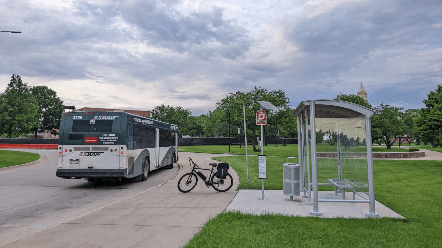
- A SMART bus on Route 790 stationed at Oakland University, showcasing key public transit options in Rochester. Source: rochesterriders.org
After decades without public transit service, Rochester and Rochester Hills residents can now take advantage of SMART’s Route 492, which launched in April 2024. This fixed-route bus service runs primarily along Squirrel Road, University/Walton Boulevard, and Rochester Road, connecting the community to the broader metro Detroit transit network. Operating Monday through Saturday from 6:00 AM to 10:00 PM (with limited early morning and late evening service), Route 492 provides affordable transportation at just $2 for four hours of unlimited rides, making it a cost-effective choice for commuters and occasional travelers alike.
Route 492 serves numerous key destinations throughout Rochester and beyond. Oakland University students can easily access downtown Rochester’s shops and restaurants, while shoppers can reach the Village of Rochester Hills, Oakland Mall, and other retail areas without driving. The route extends south through Troy, Royal Oak, and Ferndale, ultimately connecting to the Jason Hargrove Transit Center. Riders can use the Transit app to track buses in real-time, plan trips efficiently, and purchase mobile tickets. For those needing to travel further, the route offers connections to other SMART routes serving metro Detroit, expanding transportation possibilities throughout the region.
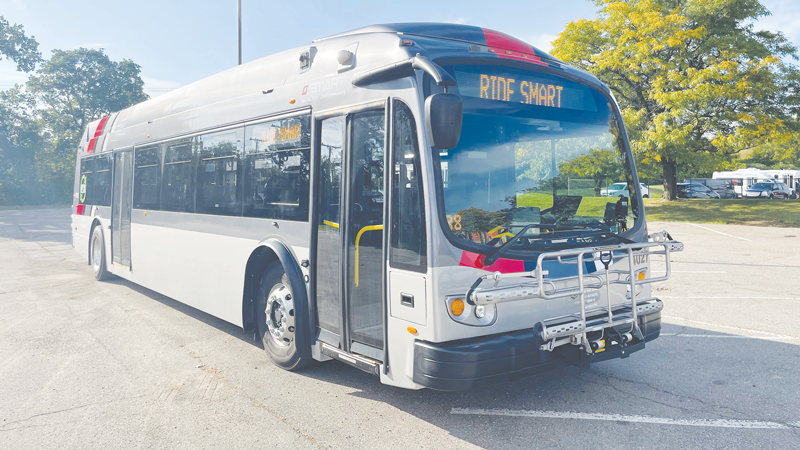
- Newly added bus route through Rochester and Rochester Hills enhances local commuting options. Source: candgnews.com
Driving in Rochester: Information about major roadways (Rochester Road, University/Walton, Squirrel Road), traffic patterns, parking options in downtown and commercial areas, and tips for navigating during peak hours and special events.
Rochester’s road network is anchored by several major routes that make navigating the city straightforward. Rochester Road serves as the primary north-south corridor, connecting the area to Troy and the M-59 corridor. University Drive/Walton Boulevard runs east-west through the community, providing access to Oakland University and Auburn Hills. Squirrel Road offers another important north-south path on the western edge of Rochester Hills. These roads typically experience moderate traffic during weekday rush hours (7-9 AM and 4-6 PM), with Rochester Road seeing the heaviest volumes, particularly near M-59 and downtown Rochester.
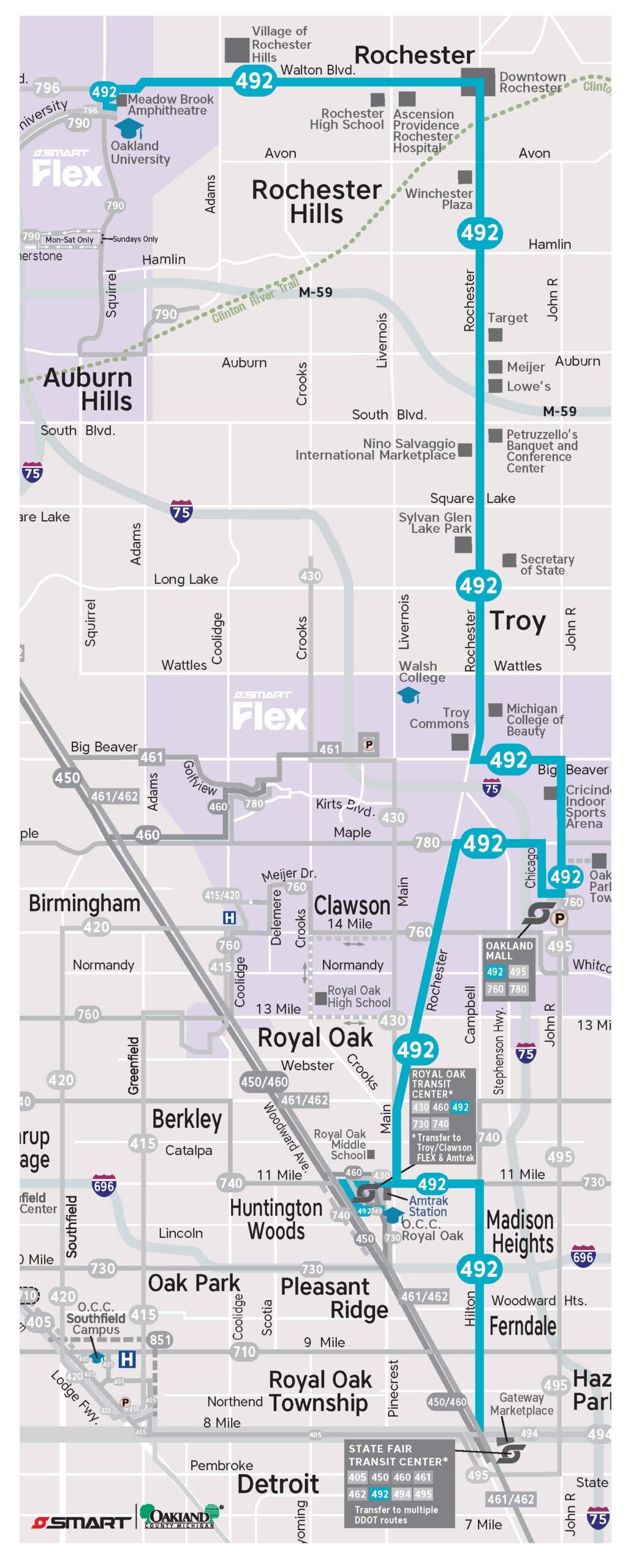
- Map of Route 492 connecting major points in Rochester, offering insight into local transit and biking corridors. Source: rochesterriders.org
Parking in downtown Rochester combines convenience with charm, offering both on-street spaces and several public lots. The city maintains free parking structures and surface lots throughout downtown, though time limits are enforced during business hours. During popular events like the Big, Bright Light Show in December and the Art & Apples Festival in September, parking demand spikes significantly. Savvy drivers know to arrive early or park slightly outside downtown at locations like the Rochester Municipal Park and utilize the pedestrian bridge to cross the Clinton River into downtown. The Village of Rochester Hills shopping center and other commercial areas throughout the community offer ample free parking, though spots nearest to popular businesses fill quickly during peak shopping hours.
Biking Infrastructure: Coverage of Rochester’s biking options, including the Clinton River Trail, bike lanes, trail connections, bike-friendly areas, and safety recommendations for cyclists commuting in the city.
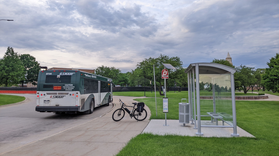
- Rochester Transit Guide providing essential tips and resources for local commuters. Source: rochesterriders.org
Rochester boasts excellent cycling infrastructure centered around the Clinton River Trail, a 16-mile converted railroad corridor that runs east-west through the community. This paved trail serves as the backbone of Rochester’s non-motorized transportation network, connecting cyclists to downtown Rochester, Rochester Hills, Auburn Hills, and beyond. The trail links seamlessly with the Paint Creek Trail heading north toward Lake Orion and the Macomb Orchard Trail to the east, creating an extensive regional trail system perfect for both recreational rides and practical commuting. These trails are particularly valuable as they provide car-free corridors for cyclists to navigate significant portions of their commute.
Beyond the trail system, Rochester has invested in on-road cycling infrastructure with designated bike lanes along portions of University Drive and Walton Boulevard. Cyclists commuting to downtown Rochester can find bike racks scattered throughout the area, with notable concentrations near Main Street businesses and the Rochester Municipal Park. For safe cycling in Rochester, riders should use front and rear lights (especially when using the Clinton River Trail after dark), wear reflective clothing, and follow all traffic laws when riding on city streets. During winter months, the Clinton River Trail receives variable maintenance, though portions near downtown Rochester are typically cleared of snow more regularly than outlying sections.
Commuting Tips and Resources: Practical advice for all transportation methods including multi-modal commuting options (bike-and-bus, park-and-ride), navigation apps (Transit app for bus tracking), seasonal considerations, and resources for transportation planning in Rochester.
Rochester’s varied transportation options make multi-modal commuting increasingly viable for residents. Combining methods often provides the most efficient commute; for example, cyclists can load their bikes onto the front racks of SMART buses (each bus accommodates two bikes) to extend their range or avoid challenging sections of road. The SMART system doesn’t yet have formal park-and-ride lots in Rochester, but commuters often use shopping center parking lots near bus stops along Rochester Road as informal park-and-ride locations, particularly those with businesses that open later in the morning. When planning multi-modal journeys, the Transit app proves invaluable for real-time bus tracking and trip planning.
Seasonal considerations significantly impact Rochester commutes. Winter driving typically requires extra caution, particularly on the hilly sections of Rochester Road and downtown side streets. Cyclists should prepare for variable trail conditions, with some sections of the Clinton River Trail receiving inconsistent snow clearing. For transit riders, SMART bus stops may have limited shelter, so winter waiting requires proper attire. For transportation resources, the City of Rochester’s website provides information on road closures and construction, while the SMART website (smartbus.org) offers comprehensive transit details. The Clinton River Trail Alliance maintains updates on trail conditions, and local cycling shops like Rochester Bike Shop can provide route recommendations and maintenance services for bike commuters.